Showing 37 items matching diamond creek mine
-
 Eltham District Historical Society Inc
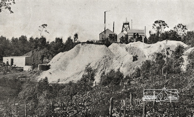
Photograph postcard, Diamond Creek Mine; postcard dated 1 March 1913
... Diamond Creek Mine; postcard dated 1 March 1913...Diamond Creek Mine... melbourne Photograph postcard Diamond Creek Mine; postcard dated 1 ...Digital file only Postcards scanned from the collection of Michael Aitken on loan to EDHS, 13 Feb 2018michael aitken collection, postcards, diamond creek, diamond creek mine -
 Greensborough Historical Society
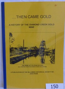
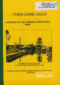
Book, Then came gold: a history of the Diamond Creek Gold Mine: by Jock Ryan, 2001_
... Then came gold: a history of the Diamond Creek Gold Mine...diamond creek gold mine...The Diamond Creek Gold Mine was active from the 1860s... of the Diamond Creek Gold Mine: by Jock Ryan. Book, 9 pages. Black ...The Diamond Creek Gold Mine was active from the 1860s and by 1912 had 12 known shafts. This book outlines ownership and contains anecdotes about the mine.A short history of the Diamond Creek Gold MineBook, 9 pages. Black and white illustrations and maps. Yellow front page with clear plastic cover.John Mackey in pencil inside front cover.diamond creek, john l ryan, jock ryan, diamond creek gold mine, gold discoveries victoria -
 Eltham District Historical Society Inc
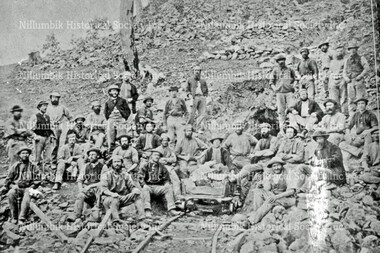
Photograph - Digital Photograph, Alan King, Site of the Diamond Creek Gold Mine, 28 December 2007
... Site of the Diamond Creek Gold Mine...Diamond Creek Mine... melbourne Digital Photograph Photograph Site of the Diamond Creek ...The largest gold mine in the area originated from a find in 1862. The mine was closed January 20, 1915 when a fire destroyed nearly all the above ground plant. Published: Nillumbik Now and Then / Marguerite Marshall 2008; photographs Alan King with Marguerite Marshall.; p75This collection of almost 130 photos about places and people within the Shire of Nillumbik, an urban and rural municipality in Melbourne's north, contributes to an understanding of the history of the Shire. Published in 2008 immediately prior to the Black Saturday bushfires of February 7, 2009, it documents sites that were impacted, and in some cases destroyed by the fires. It includes photographs taken especially for the publication, creating a unique time capsule representing the Shire in the early 21st century. It remains the most recent comprehenesive publication devoted to the Shire's history connecting local residents to the past. nillumbik now and then (marshall-king) collection, diamond creek, diamond creek mine, fraser street, gold mining, james cook drive, mine hill -
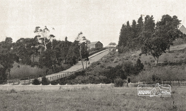
 Eltham District Historical Society Inc
Photograph, Diamond Creek Gold Mine
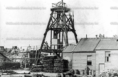
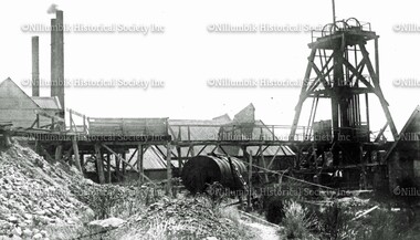
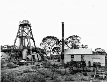
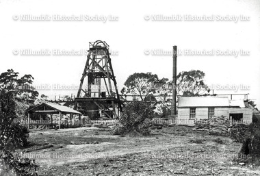
... Diamond Creek Gold Mine.... The Diamond Creek Gold Mine was the largest in the Diamond Valley... melbourne Photograph Photograph Diamond Creek Gold Mine Digital ...Situated at the end of Fraser Street, Diamond Creek. The Diamond Creek Gold Mine was the largest in the Diamond Valley Shire with a shaft depth of over 290 metres at the peak of its development in 1915. The surface plant was quite large with four boilers and five steam engines working the battery, winder, water pump, air compressor and lighting generator.This photo forms part of a collection of photographs gathered by the Shire of Eltham for their centenary project book, "Pioneers and Painters: 100 years of the Shire of Eltham" by Alan Marshall (1971). The collection of over 500 images is held in partnership between Eltham District Historical Society and Yarra Plenty Regional Library (Eltham Library) and is now formally known as 'The Shire of Eltham Pioneers Photograph Collection.' It is significant in being the first community sourced collection representing the places and people of the Shire's first one hundred years.Digital imagesepp, shire of eltham pioneers photograph collection, diamond creek, goldmine, gold mine, poppet head -
 Eltham District Historical Society Inc
Book, Jock Ryan, Then came gold : a history of the Diamond Creek Gold Mine / Jock Ryan, 2001
... Then came gold : a history of the Diamond Creek Gold Mine...diamond creek gold mine... Mine / Jock Ryan Paperback; 9 p. : ill. ; 30 cm. diamond creek ...Paperback; 9 p. : ill. ; 30 cm.diamond creek gold mine, gold mining, gold miners -
 Nillumbik Historical Society Incorporated
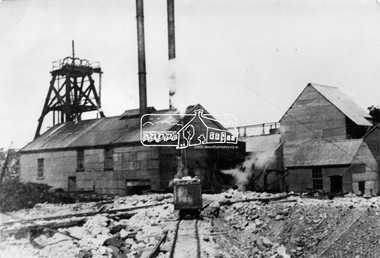
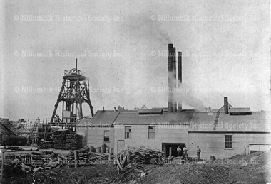
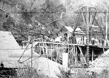
Photograph - Black & white photograph, Diamond Creek Gold Mine with Poppet Head and a Chimney for Each Boiler
... Diamond Creek Gold Mine with Poppet Head and a Chimney for...Diamond Creek Gold Mine... Photograph Diamond Creek Gold Mine with Poppet Head and a Chimney ...A comprehensive view of the buildings of the Diamond Creek Gold Mine during the period the boiler houses were shared with the Union Gold MineBlack & white photographdiamond creek gold mine, union gold mine, diamond creek, nillumbik, poppet head -
 Nillumbik Historical Society Incorporated
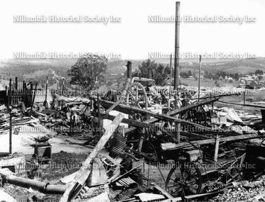
Photograph - Black & white photograph, Diamond Creek Gold Mine after fire 1915
... Diamond Creek Gold Mine after fire 1915...Diamond Creek Gold Mine... Photograph Diamond Creek Gold Mine after fire 1915 Black & white ...Black & white photographdiamond creek gold mine, diamond creek -
 Eltham District Historical Society Inc
Photograph, Diamond Creek Gold Mine, c.1912
... Diamond Creek Gold Mine, c.1912...Diamond Creek Gold Mine... melbourne Photograph Diamond Creek Gold Mine, c.1912 Black and white ...Similar to See EDHS_02659Black and white copy of photo printed on glossy photographic paper 30.5 x 40.5 cm (12 x 16 inch); image size approx. 18.5 x 28 cmdiamond creek gold mine -
 Gippsland Art Gallery
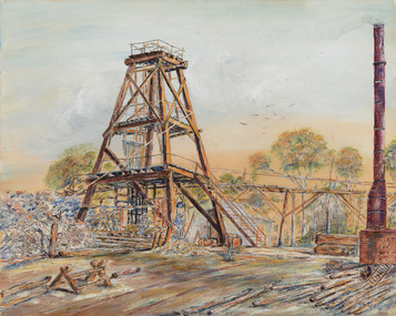
Painting, Taylor, George, Diamond Creek Mine, 1968
... Diamond Creek Mine... Painting Diamond Creek Mine Oil on canvas on board Gippsland ...Purchased, 1969Oil on canvas on boardgippsland, artwork, permanent collection -
 Nillumbik Historical Society Incorporated
Photograph - Black & white photograph, Golden Hind Mine, Diamond Creek
... Golden Hind Mine, Diamond Creek...Diamond Creek Gold Mine... Photograph Golden Hind Mine, Diamond Creek Black & white photograph ...Black & white photographgolden hind gold mine, diamond creek gold mine, nillumbik -
 Nillumbik Historical Society Incorporated
Photograph - Black & white photograph, Union Gold Mine, Diamond Creek 1871
... Union Gold Mine, Diamond Creek 1871...Diamond Creek Gold Mine... Photograph Union Gold Mine, Diamond Creek 1871 Black & white ...Black & white photographunion gold mine, diamond creek gold mine, nillumbik -
 Eltham District Historical Society Inc
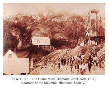
Work on paper (Sub-Item) - Photograph, The Union Mine, Diamond Creek circa 1900
... The Union Mine, Diamond Creek circa 1900... melbourne Photograph Work on paper The Union Mine, Diamond Creek ...The Union Mine operated until 1916.diamond creek, gold mine, miners, nillumbik historical society -
 Nillumbik Historical Society Incorporated
Photograph - Black & white photograph, Primitive Methodist Church and School with Diamond Creek Gold Mine on hill above
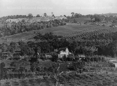
... Primitive Methodist Church and School with Diamond Creek... Methodist Church and School and the Diamond Creek Gold Mine both ...The earliest known photograph of Patrick Cummings barn - the Primitive Methodist Church and School and the Diamond Creek Gold Mine both established in the early 1860's.Black & white photographnoneprimitive methodist church, methodist church, diamond creek school, nillumbik school -
 Nillumbik Historical Society Incorporated
Photograph - Black & white photograph, Diamond Creek Gold Mine poppet head and buildings
... Diamond Creek Gold Mine poppet head and buildings... Photograph Diamond Creek Gold Mine poppet head and buildings Black ...Black & white photograph -
 Nillumbik Historical Society Incorporated
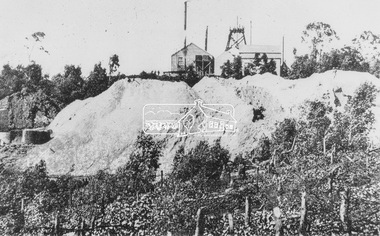
Photograph - Black & white photograph, Diamond Creek Gold Mine
... Diamond Creek Gold Mine... Photograph Diamond Creek Gold Mine Black & white photograph ...Black & white photograph -
 Nillumbik Historical Society Incorporated
Photograph - Black & white photograph, Diamond Creek Gold Mine
... Diamond Creek Gold Mine... Photograph Diamond Creek Gold Mine Black & white photograph ...Black & white photograph -
 Nillumbik Historical Society Incorporated
Photograph - Black & white photograph, Diamond Creek Gold Mine
... Diamond Creek Gold Mine... Photograph Diamond Creek Gold Mine Diamond Creek Nillumbik Gold ...diamond creek, nillumbik, gold mining -
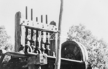
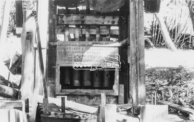 Eltham District Historical Society Inc
Photograph, Fraser & Chalmers LD. Erith England No 110 Stamp Mill for processing gold ore, possibly used at Diamond Creek Gold mine
... processing gold ore, possibly used at Diamond Creek Gold mine... Creek Gold mine Black and white copy of photo printed on glossy ...Black and white copy of photo printed on glossy photographic paper 30.5 x 40.5 cm (12 x 16 inch); image size approx. 18.5 x 28 cmengland, erith, fraser and chalmers, gold mining, machinery, stamp mill -
 Eltham District Historical Society Inc
Film - Video (VHS), Nillumbik Shire Council, The Nillumbik Story, 1996
... Diamond Creek Mine... the Diamond Creek mine, which was thriving until it burnt out in 1915... to the Caledonian gold rush. Jock Ryan discusses the Diamond Creek mine ...PART 1 – NILLUMBIK (00:00-07:17) Opening features various scenes around Nillumbik Shire. For 40,000 years Nillumbik was the home of the Wurundjeri people. Robert Hoddle gave the district its name. Jock Ryan, then president of Nillumbik Historical Society discusses the names Nillumbik and Diamond Creek. In the late 1830s white occupation began with gold found in Warrandyte in 1851 and 12 years later at Diamond Creek -the Diamond Reef which led to the Caledonian gold rush. Jock Ryan discusses the Diamond Creek mine, which was thriving until it burnt out in 1915. Large numbers of workmen moved into area in late 1870s to construct the Maroondah Aqueduct. With growing population of Melbourne, the nearby Yan Yean system had severely disrupted the flow of the Plenty River, forcing the closure of three flour mills there. The aqueduct came to the rescue carrying water 66km from Healesville to Preston. When the Diamond Creek gold mine burnt down the local economy suffered but fruit growing industry had already been established and Diamond Creek became a thriving fruit growing centre. Interview with Jack Powell, a long-time fruiterer at St Andrews market, his family had lived in the area for a hundred years, 3 to 4 generations, “a lot of hard work”. By the time the railway arrived fruit growing was no longer competitive. The railway brought the city closer and day trippers. The Green Wedge separates the shire from the more densely developed neighbours such as Whittlesea, Doncaster, Templestowe, Bulleen and Greensborough. Population at the time (1996) was 19,000 but links to the past remain strong. Mudbrick houses along the Heritage Trail The saving of Shillinglaw Cottage from demolition in 1963 and relocation brick by brick. PART 2 – ENVIRONMENT (07:18-14:44) Peter Brock (with Bev Brock in background) at St Andrews market discusses his childhood growing up in the district and the environment and the values it instilled upon him and his own family. The Brocks have been in the district since the 1860s. Nillumbik Shire responsible for managing three catchment areas; Diamond Creek, Arthurs Creek and Watsons Creek. Follows the course of the Diamond Creek commencing in Kinglake through the district to its confluence with the Yarra River at Eltham at Eltham Lower Park. Highlights Eltham Lower Park community revegetation program and the newly constructed (1996) viewing platform built of new and recycled timbers at the confluence of the Diamond Creek and Yarra River. Also featured are outdoor recreation on the river and at Eltham Lower Park including the Diamond Valley miniature railway. Sugarloaf reservoir and recreational activities and fishing. Aerial view of Memorial Park and Shire of Eltham War Memorial tower at Garden Hill, Kangaroo Ground. Significant tourism opportunities for the shire with 3 million potential day-trippers in metropolitan Melbourne. Council and community working together to find a way to promote the shires natural and artistic assets. At Arthurs Creek, the Brock family and neighbours working together to take care of their waterway. Peter Brock’s uncle, Sandy Brock talks about environmental management and the Arthurs Creek Landcare group and actions to eradicate blackberry problem. Having previously planted Cypress rows they are replacing them with indigenous species to improve the water supply, keeping cattle out of the creek bed to improve the quality downstream flowing into the Yarra. Eltham East Primary School Band playing “All things bright and beautiful” merges into scenes of the bushland sanctuary set aside by the school in 1980 with unidentified teacher discusses the sanctuary and their education program and school children’s comments. Plight of a family of Wedgetail eagles nesting in the path of a developer’s bulldozer at North Warrandyte and actions to save their nesting areas. PART 3 – ARTS (14:45-22:00) Arts and Jazz festival at Montsalvat featuring interviews with Sigmund Jorgensen discussing Montsalvat and its principles. Also Matcham Skipper. Clifton Pugh’s funeral at Montsalvat and his legacy at Dunmoochin near Cottlesbridge with artists in residence, at the time, Chicago artist Charles Reddington who discusses the benefits of the experience. An unidentified female artist also talks about the program and why people are drawn to the area. Unidentified man on street talking about the amount of talent in the area, artists, poets, musicians, authors. Artist Ming Mackay (1918-2009) interviewed talking about the people she mixes with on “the Hill”. Works of local artists are displayed Eltham Library Community Gallery and Wiregrass gallery with a new coffee shop at the Wiregrass making it an even more popular destination. Music at St Andrews Hotel (may be a little bit country) and the Saturday market where likely to hear anything. Sellers and patrons at the market asked about what attracts them to the market and where they came from. Scenes of poets/authors giving readings. CREDITS Music by John Greenfield from the CD Sweet Rain “The Snow Tree”, Uncle Music UNC 2001 Cameras - David Mirabella and Peter Farragher Editor – Olwyn Jones Written and Produced by Jason Cameron A Jason Cameron Proction for Nillumbik ShireProvides a record of the relatively newly created Shire of Nillumbik at the time and the features and attactions of the shire in its people arts, culture and environmentVHS Cassette (two copies) Converted to MP4 file format 0:22:00, 1.60GBvideo recording, arthurs creek, arthurs creek landcare group, artists, artists in residence, arts, arts festival, authors, blackberry, brock family, bulldozer, bulleen, bushland sanctuary, caledonian gold rush, charles reddington, clifton pugh, cottlesbridge, cypress rows, developer, diamond creek, diamond creek mine, diamond reef, diamond valley miniature railway, doncaster, dunmoochin, education program, eeps, eltham, eltham east primary school, eltham east primary school band, eltham library community gallery, eltham lower park, environment, fishing, flour mill, fruit growing, fruiterer, garden hill, gold mining, green wedge, greensborough, heritage trail, hurstbridge railway line, jazz festival, jock ryan, kangaroo ground, kangaroo ground tower, kinglake, maroondah aqueduct, matcham skipper, memorial park, ming mackay (1918-2009), montsalvat, mudbrick houses, music, musicians, nesting area, nillumbik historical society, nillumbik shire, north warrandyte, old timer, orchards, peter brock, plenty river, poets, population, recreation, recreational activities, revegetation, robert hoddle, sandy brock, shillinglaw cottage, shire of eltham war memorial, sigmund jorgensen, st andrews hotel, st andrews market, sugarloaf reservoir, templestowe, the hill, tourism, viewing platform, warrandyte, water catchment area, watsons creek, wedgetail eagle, whittlesea, wiregrass gallery, wurundjeri, yarra river, jack powell -
 Eltham District Historical Society Inc
Photograph postcard, Entrance to Diamond Creek, c.1913
... diamond creek mine... postcards diamond creek diamond creek mine ...Digital file only Postcards scanned from the collection of Michael Aitken on loan to EDHS, 13 Feb 2018michael aitken collection, postcards, diamond creek, diamond creek mine -
 Nillumbik Historical Society Incorporated
Photograph - Black & white photograph, Fred Orme with the manager of the Golden Hind Mine, Diamond Creek
... Fred Orme with the manager of the Golden Hind Mine, Diamond... Square Diamond Creek melbourne Black & white photograph ...Black & white photograph -
 Nillumbik Historical Society Incorporated
Photograph - Black & white photograph, Union Gold Mine, Diamond Creek
... Union Gold Mine, Diamond Creek... Photograph Union Gold Mine, Diamond Creek Black & white photograph ...Black & white photograph -
 National Wool Museum
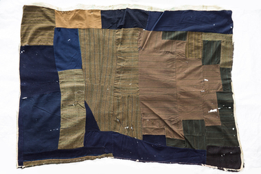
Quilt, 1880s
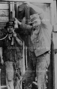
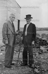
... ), Diamond Creek and Costerfield in Victoria. His last residence...), Diamond Creek and Costerfield in Victoria. His last residence ...The wagga was owned by the great uncle of the donor's husband, George Stephens. Mr Stephens was a mining engineer in the late 1800s to early 1900s in Stawell, Main Lead (near Beaufort), Diamond Creek and Costerfield in Victoria. His last residence was at Bosterfield, where the wagga was used as a bed quilt in the mid 1940s. It may have also been used in the childhood home of Mr Stephens at Stawell. Mr Stephens saved the life of a blacksmith at Diamond Creek Gold Mine circa 1910.A wagga made from men's suits and coats, unpicked and sewn together. Pieces are in blue, brown checked and striped materials. There are remnants of a backing around the edges.wagga, running stitch collection, diamond creek, victoria, stawell, beaufort, costerfield -
 Eltham District Historical Society Inc
Negative - Photograph, Carl Walter 1831-1907, Coffer dam in the Yarra River at Anderson's Creek, 1864
... extensive of the deep workings was the Diamond Creek Mine just... extensive of the deep workings was the Diamond Creek Mine just ...1864 photograph of the Coffer Dam in the River Yarra situated (approximately) opposite Whipstick Gully. Remains of bridge built in 1860(?) wrecked by 1863 flood in background. Reproduced page 29 of ‘Pioneers & Painters’ Gold was first discovered in this area at Andersons Creek (Warrandyte) in June 1851 by Louis Michel. Discoveries north of the Yarra did not occur until about 1854. Although it took some months for a true rush to develop it was not long before alluvial workings were being carried on in most of the Shire of Eltham. The last area in which gold was discovered was Kinglake. As the gold became harder to find, deep mining took over from alluvial diggings in the gullies. Perhaps the most extensive of the deep workings was the Diamond Creek Mine just outside the boundary of the Shire. This form of mining was continued into the 1930s. There are believed to be some mines in the area still capable of producing gold but present prices make working these uneconomical. Some gold is still found by weekend prospectors. Photo: Carl Walter 1831-1907 – inscribed on tent “C. Walter Photo” The State Library of Victoria holds over 150 photos by Carl Walter, most of which are portraits of Aboriginal natives including William Barak.This photo forms part of a collection of photographs gathered by the Shire of Eltham for their centenary project book,"Pioneers and Painters: 100 years of the Shire of Eltham" by Alan Marshall (1971). The collection of over 500 images is held in partnership between Eltham District Historical Society and Yarra Plenty Regional Library (Eltham Library) and is now formally known as 'The Shire of Eltham Pioneers Photograph Collection.' It is significant in being the first community sourced collection representing the places and people of the Shire's first one hundred years.Digital image 4 x 5 inch B&W Neg (2) Print 20 x 25 cmshire of eltham pioneers photograph collection, anderson's creek, coffer dam, floods, gold mining, other areas, pioneers and painters, warrandyte, warrandyte bridge, yarra river -
 Eltham District Historical Society Inc
Photograph, Tess Justine (Nillumbik Shire Council), Murray's Bridge over the Diamond Creek, Eltham North, 19 Feb 2022
... in anticipation of the old Diamond Creek Gold Mine being re-opened... of the old Diamond Creek Gold Mine being re-opened. The mine had been ...Murray's Bridge over the Diamond Creek on the Diamond Creek Trail just prior to demolition and replacement with a new steel bridge. Heritage advice obtained by Nillumbik Shire Council, following a suggestion by the Eltham District Historical Society (EDHS), is that the original bridge appears to have been a simplified version of the Country Roads Board’s (CRB) standard timber bridge design of the early-to-mid 1920s. In c1990 Murray’s bridge was renovated with three recycled steel girders as part of a bike/pedestrian path in the reserve. During these alterations many parts of the bridge were removed, and some were replaced. Heritage advice indicates the condition of Murray’s bridge is poor. The remaining original parts are all in poor condition, with severe weathering, splitting and rot, especially to the stringers retained on the bridge. Heritage advice is that Murray’s Bridge does not have sufficient significance in the cultural history of the Nillumbik area to warrant inclusion in the Nillumbik Shire Heritage Overlay and also does not have sufficient significance as a rare survivor to warrant inclusion in the Nillumbik Shire Heritage Overlay. There are no indications in the historical record that this site was individually important to the cultural history of this area. EDHS is comfortable with the heritage advice provided to Council and has worked closely on this project with Council. EDHS has suggested some of the removed timbers be used in the vicinity of the bridge for landscaping and possibly seating, so as to retain these remnants close to the site of the original bridge, which is the last old timber bridge along the lower reaches of the Diamond Creek. Mary (Sweeney) Murray and John Wright Murray selected 80 acres, Lot C Section 16 and Lot 5 Section 17 Parish of Nillumbik, under an occupation license in 1866. John died in 1867 and freehold was granted to his son John in 1873. The farm was known as ‘Laurel Hill’. John Junior was an Eltham Shire councillor and sometime president from 1887 up until 1897. He added Lot A Section 16 to the farm in ca1888. John and his younger brother James arranged to rent/purchase Lot B Section 17, across Diamond Creek to the west, in ca1900. It appears that John and James farmed separately for a few years, with a new homestead built for James ad family on the high point of Lot B Section 17 in ca1910. John sold off Lot 5 Section 17 in 1912. When John died in 1912 James took over the land on both sides of the Diamond Creek. The old homestead on the west side of the Creek disappeared. A farm bridge over Diamond Creek from this period may have been located close to the northern boundary of the farm. John Langlands, owner of the farm known as ‘Ihurst’ on the west side of Diamond Creek to the south of the Murray’s land, died in 1907. In 1909 his land was then subdivided into 100 lots to become the ‘Glen Park Estate’. Other similar subdivisions of nineteenth century farms around Eltham in this period included the ‘Franktonia (or Beard’s) Estate’ to the northeast and ‘Bonsack’s Estate’ between Eltham and Greensborough. Soon after the opening of the railway extension line from Eltham to Hurstbridge in 1912, Glen Park and nearby residents including James Murray agitated for a railway station or siding to be located half-way between Eltham and Hurstbridge, so that the Glen Park residents who used the railway daily did not have to walk into the Eltham or Hurstbridge stations. Some believed Coleman’s Corner (opposite Edendale Farm) was an appropriate spot for the platform. James Murray was among those who thought the railway should be located on his land, closer to half-way between Eltham and Hurstbridge stations. The Railways Commissioners warned that the locals would have to fund these works themselves. The Glen Park Estate residents initially had difficulty accessing Eltham by road, with only an old low-level bridge over Diamond Creek at the south end of their estate. A new timber trestle bridge across the creek, now on Wattletree Road, was opened in 1915. Road access to the north was gained in 1927 when the new Murray’s Road, which crossed the Murray’s land, was built. Residents continued to agitate for a Glen Park station. By 1926 the Railways Commissioners’ preferred site was on the Murray’s land. They arranged an estimate of cost of a full-length platform. The estimate was too much for the locals, who in 1928 argued unsuccessfully for a shorter and hence cheaper platform. By 1929 Murray had agreed to donate the land, but the locals would still have to fund the works. Murray decided, unilaterally it would appear, to commence work on a timber trestle road bridge over Diamond Creek to link the new Murray Road to the proposed station. Late in 1929 he stopped work on the bridge, for reasons unknown, but started work again and completed the bridge in 1931. There is no further newspaper evidence of the campaign for the Glen Park station until 1939, when Murray and another local, Mr Maxwell, met the Railways Commissioner. The Glen Park locale now included 45 homes on the west side of the creek and 20 on the Eltham side. Most of the residents used the train every day. The Commissioner remained adamant that only a full-length platform could be built for safety reasons. It appears the campaign dissolved at this point. The increasing move to cars may have had an impact. There is no evidence of Murray’s bridge ever being connected to Murray’s Road, or of it having wide use for any purpose by locals. James Murray died in 1947 and the farm was taken over by his son James (Jim). Jim started to sell off parts of the farm in the 1980s, retaining a few acres around the ca1910 homestead and building a new house there. Recreation reserves were established along the creek. In ca1990 Murray’s bridge was renovated with steel girders as part of a bike/pedestrian path in the reserve. The old farmhouse was demolished in ca2014. * * * A theory posted on local community Facebook groups was that the bridge was built in the 1860s and was built to be more robust than was necessary for the movement of cows from one side of the creek to the other. It was suggested the robustness was necessary to support the weight of gold ore being transferred from a mine on Murray’s land to a railway siding near Murrays Bridge (presumably for transfer and processing at Diamond Creek). Perhaps this may have been one of the motivators for Murray, who really knows? Knowing when mining operations ceased on his land and how that fits the overall timeline would be useful but at the time the bridge was built, local gold production was minimal at best. The known facts are: • The railway line came to Eltham in 1902. • The extension of the railway from Eltham to Hurstbridge was constructed in 1912 so no railway line even existed through Murray's property until 1912 and the Victorian Railways maps at the time show no such siding on Murray’s property. • In 1923 a new company was formed in anticipation of the old Diamond Creek Gold Mine being re-opened. The mine had been previously closed and flooded. It was noted in the press at the time that the mine was within a mile of the railway. Nothing really came of this. • Construction of Murrays Bridge was commenced by James Murray in early 1929 in anticipation of a proposed flag station being nominated on his land, but work ceased shortly afterwards. The proposed flag station was commonly referred to as Glen Park as the residents of the Glen Park Estate wanted Option 1, located near them with the platform adjacent to Colemans corner. This was probably never going to fly as it was virtually in eyesight of Eltham station. Allandale Road was the third option, but the Commissioners' preferred option was No. 2 - on Murray's property. • The Railway Commissioners were not going to finance any such station and the works had to be funded by private landowners and residents, hence Murray investing in this himself. • Murray recommenced work two years later and finished his bridge in 1931 but unfortunately for him, the proposed flag station never eventuated. The bluestone siding you reference may well have been built by Murray as part of the proposed station platform. • Up until then, apart from the Main Road bridge, which was washed away in 1924, virtually all local crossings over the Diamond Creek were low lying bridges – Kaylocks Bridge at Brougham Street, Diamond Street bridge, Glen Park Road bridge. It is expected that Murray also had a low-lying bridge to connect his land either side of the creek. These were all washed away or severely damaged multiple times in the 1920s. Lessons were learnt, and Murrays Bridge appears to have been built in accordance with Country Road Board standards of the time. Flood damage was ongoing, and even more recently constructed raised bridges kept getting washed away, e.g., the new Wattle Tree Road bridge in 1958 just months after completion. Murray’s bridge was reinforced with steel some 30 years ago presumably to provide additional floodwater resistance, given the history of bridges disappearing in floodwaters. • In March 1932 it was reported in the Advertiser that there were still some prospectors operating around Eltham North who apart from further scarring the face of the earth over the previous two years had gained significant experience but little gold - hardly a driving factor for constructing a dedicated railway siding and bridge to transfer gold ore. It is far more probable that James Murray was hoping to have the railway station located on his property and invested his money by building the bridge to lead to it as well as a station platform. Had the station eventuated, it may well have driven up the value of his land for subdivision and new housing estates like the Glen Park Estate. That did not eventuate. Whilst the bridge was indeed old (90 years), the core structure being completed in 1931, it had been modified substantially from original and hence had no significant historic value – i.e., it was not a representative example of its type, construction, and age. Given that the bridge was not worthy of saving, the Eltham District Historical Society with Council’s support, and the Eltham Woodworkers group endeavoured to see what suitable sized timbers were salvageable to fabricate a commemorative seat. Unfortunately, the experts at the Woodworkers group were unable to salvage any suitable length/width timbers to fabricate the seat due to the presence of rot. Last remaining wooden trestle bridge on the Diamond Creek Trail just prior to demolition and replacementBorn digital image (27)diamond creek (creek), diamond creek trail, murrays bridge, ‘laurel hill’, john wright murray, mary (sweeney) murra, john murray jnr, james murray, john langlands, ‘ihurst’, ‘glen park estate’, beard's estate, franktonia, bonsack's estate, glen park estate, glen park railway station -
 Greensborough Historical Society
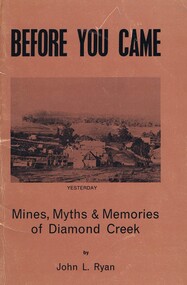
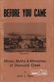
Book, Before you came: mines, myths and memories of Diamond Creek. By John L Ryan, 1972
A history of Diamond Creek from earliest records of white visitors (1836) to the 1970s. John Ryan was born in Diamond Creek and lived there all of his life.A detailed history and anecdotes of the Diamond Creek area and its early pioneers.55 pages. Soft cover, light brown with copy of early painting of Diamond Creek on front cover. Black and white illus. 3 copiesOn page one in pencil: John Mackeydiamond creek, john l ryan -
 Eltham District Historical Society Inc
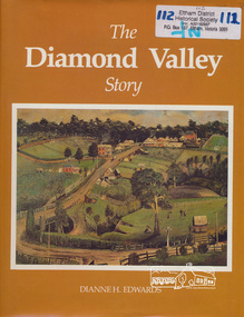
Book, Dianne H. Edwards, The Diamond Valley Story / Dianne H. Edwards, 1994
Review in Heidelberg Historian (Newsletter of Heidelberg Historical Society) No 80 October 1980 "This substantial and significant history is one of the really essential books which all members interested in the history of Heidelberg and district should have, for, as indicated in this work, the Diamond Valley and Heidelberg were linked together in a municipal, economic and geographical sense throughout their history and still have strong links. This work of 191 pages, with numerous illustrations, covers the entire period of the history of the Shire area, from Greensborough to Hurstbridge (to 1979). Starting with a geographical setting, Miss Edwards traces the early development of the historic district from Hume & Hovell to the first explorers and settlers with some discussion on the meeting of John Batman with the aborigines here. Details of the early residents follow with numerous portraits, including the Beales of St Helena and the Ryries of Yering. In part 2, the account continues of the later settlers and squatters like Henry Foley and C. S. Haley. The gold discoveries on the Plenty and at the Diamond Creek and Queenstown area then follow with the development of the townships of Hurstbridge and Diamond Creek, with details of the mines and miners of the last century until its decline in the 1870's." "During the writing of the book, 40 tapes were made by the authoress Dianne Edwards of local residents reminiscences".. Diamond Valley News February 6, 1979This book was published by the former Shire of Diamond Valley in 1979. It remains one of the key local history titles particularly for the Diamond Creek and Greensborough areas.Paperback; xiv, 194 p. : ill., ports. ; 29 cm.ISBN 0959542205diamond valley, greensborough, hurstbridge, john batman, st helena, henry foley, queenstown, diamond creek, gold mining -
 Eltham District Historical Society Inc
Book, John L. Ryan, Before you came : mines, myths & memories of Diamond Creek / by John L. Ryan, 1972
... melbourne Book Before you came : mines, myths & memories of Diamond ...Subtitled mines, myths and memories of Diamond Creek the book covers the following topics: early days, first settlers, Nillumbik- the town, state school, the churches, growth of a town, early pioneers and stories of the past. PhotographsPaperback; 55 p. : ill., port. ; 21 cm.ISBN 0959895019diamond creek, nillumbik, gold mining, gold miners -
 Eltham District Historical Society Inc
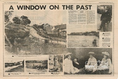
Newspaper - Newsclipping, Roger Sanders, A WINDOW ON THE PAST, 11 Aug 1976
Published in "The Sun", Wednesday, August 11, 1976, pp 38-39 [Text of article:] A WINDOW ON THE PAST by Roger Sanders. A fascinating window has been opened on the early life of the Eltham district. It is a rare collection of 3,000 perfectly preserved glass plate photograph negatives. The collection is the work of the late Albert Jones, a Diamond Creek orchardist and amateur photographer. About 500 of the negatives have been printed and 100 are on display at Gallery 4, Eltham, as part of the Eltham Festival, which started on Friday. They capture in fine detail rural and village life around Eltham, Hurstbridge, Kangaroo Ground, Yarra Glen and Diamond Valley from 1900 to 1930. While the natural beauty of the district was painted in this period by Arthur Streeton (later Sir Arthur), Tom Roberts and Charles Conder, among others, photography was relatively new. Yet Albert Jones used the new medium to compile a weighty album of pioneers at work, at home, at sport and on holidays. He was at the first Yarra Glen race meeting, early Diamond Valley football matches and photographed soldiers from the district leaving for war. He photographed early gold mines, men with horses laying the Diamond Creek-Hurstbridge rail track and the arrival of the first steam train at Hurstbridge. He took his cameras on holiday around Victoria and the collection includes scenes from St. Kilda and Portsea and many country towns. The Jones collection of negatives was found by Mr A. J. "Ned" Spark, of Balwyn, under a house he bought from Mr Jones' widow. The plates almost went to the tip with a pile of rubbish before Mr Spark realised their potential value. Mr Spark, who is retired, will continue the identification and recording of the photographs when he returns from holidays. The exhibition of the Jones' photographs is open each afternoon until August 21 at Gallery 4, 1016 Main Rd., Eltham. [Captions of photographs included in article:] • The priceless collection of glass plate negatives were found under this house in Eltham [actually Wattle Glen], home of Albert Jones and his wife. • A quiet country pub - Panton Hills Hotel. • Teams of draught horses were used in the building of the Diamond Creek-Hurstbridge railway in 1910. • Chinaman Jimmy using a gold cradle in Wattle Glen Gully. • The photographer and orchardist Albert Jones. His work is on show as part of the Eltham Festival • St Kilda Pier – several of the houses are still standing, but the waterfront has changed dramatically since this was taken before 1920. • A picnic was a dressy affair at the start of the century – the women in this family group are decked in lace and pearls.Newspaper articlealbert jones, golden glen, wattle glen